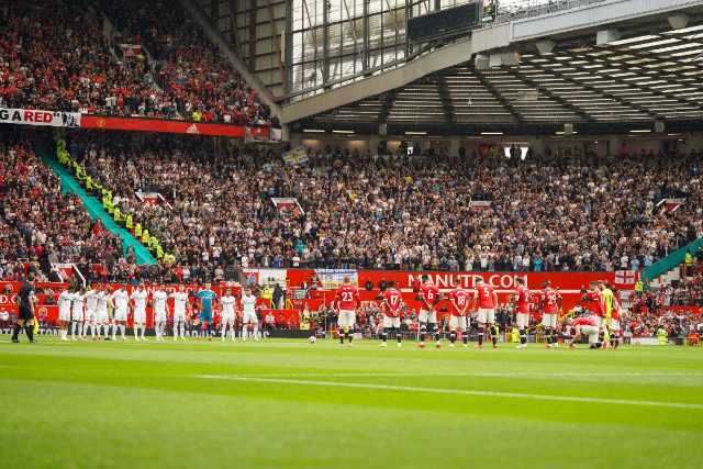
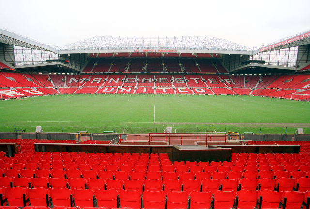
The away end at Old Trafford is one of the best in the country in terms of acoustics and view. Visiting supporters are situated in the corner between the Sir Bobby Charlton Stand and the East Stand, where roughly 3,000 can be accommodated for league matches.
From here, fans can see Old Trafford in all its glory, with the towering Sir Alex Ferguson Stand to the right and the Stretford End directly opposite. The low roof that hangs over the away section ensures that a brilliant atmosphere can be generated, too.
In recent years, 2,500 safe standing spaces have been installed in the away end, which has only made this an even more attractive stadium to visit as an away supporter.

One downside to the Old Trafford away end is the concourse as it is very cramped. This can make half-time and pre-match quite uncomfortable, especially if you want to get some food or need the toilet.
The turnstiles to the away end open two hours before kick-off but spending as little time in the concourse as possible is advised.
For cup matches, away fans can be allocated up to 9,000 tickets at Old Trafford. When this happens, the usual away end is extended slightly, while half of the East Stand’s upper tier is also allocated.
What size bag can I take into Old Trafford?
The club is quite strict about the size of bag that can be taken into Old Trafford. Anything bigger than a handbag-sized (max 20cm x 15cm x 5cm) bag has to be checked into storage for the duration of the game. The club charges £5 (to be donated to the Manchester United Charitable Foundation) for storage.
New safe-standing section opened in the Stretford End
Manchester United introduced a new safe-standing section in the second tier of the Stretford End ahead of the match against Everton on Monday, 24 November.
The rail seating, which has a capacity for 6,000 fans,is one of the largest of its kind in the Premier League and has taken the overall safe standing capacity at Old Trafford to 13,577.
The new rails have been officially certified by the Sports Grounds Safety Authority for safe standing. The other safe standing sections in Old Trafford are located in the four quadrants.
Pop-up pub to open at Old Trafford
Manchester United have revealed that they are opening up a pop-up pub at Old Trafford for their first three home Premier League games of the season against Arsenal, Burnley and Chelsea.
The ‘pub’ will be under a giant marquee in the W1 car park, and will provide supporters with a place to soak up the atmosphere, have a drink and grab some food with friends, family and fellow supporters.
The marquee will be located just a stone’s throw away from the Stretford End and has room for 1,000 supporters. Entry will be free for anyone with a match ticket.
The club say that the pop-up pub is the ‘first step in delivering more for supporters on matchdays, following feedback from the Old Trafford Regeneration research.’
If the pub proves to be a popular addition, then it could become a permanent addition for the 2025/26 season.
Manchester United want to host the 2035 Women’s World Cup final
Manchester United are reportedly set to push to become the hosts of the 2035 Women’s World Cup final.
Although the United Kingdom has yet to be officially announced as hosts of the tournament, they are the sole bidders, and it is now nothing more than a formality.
While Wembley would usually host such an event, Manchester United believe that their new 100,000-seater stadium would be a better choice.
Although construction on the new stadium is yet to begin, the club are pushing forward with their plans, and the plan is to have it completed well before the 2035 Women’s World Cup.
New council group to push forward regeneration plans around Old Trafford
The Old Trafford regeneration project, which has Man Utd’s new 100,000-seater stadium at its core, has taken a huge step forward at local level after Trafford Council confirmed that they are planning on creating a new statutory body with the power to purchase land and co-ordinate plans in the area.
The new group will be known as the Old Trafford Regeneration Mayoral Development Corporation and will be formally created by the Mayor of Greater Manchester, Andy Burnham in partnership with Trafford Council.
Burnham is keen to be involved in the project, and was also selected by Manchester United to be part of their stadium taskforce alongside the likes of Lord Sebastian Coe and Gary Neville, when they were looking into the feasibility of a new stadium in the area.
This summer, the new group will push forward with a consultation initiative where local people will be asked to share their views on the project. It is estimated that around 48,000 new job and 5,000 new homes will be created as part of it.
Trafford Council’s Exectuive Member for Economy and Regeneration, Liz Patel, said:
“The regeneration of Old Trafford is complex and will take years to progress. The MDC will be able to drive this important flagship work forward, overseeing costs, quality and timely delivery.
“It will mean we can pool expertise, resources and powers to attract investment and support aspects such as master planning, site preparation and infrastructure developments.”
Season ticket prices increase at Old Trafford
Ahead of the 2025/26 season, Manchester United have announced an increase in season ticket prices at Old Trafford, with all adult season tickets receiving a 5% increase across the board.
Those with senior season tickets at Old Trafford were stung further. The discount applied to these tickets has been increased from 25% to 50%.
Man Utd to move out of Old Trafford
In March 2025, Man Utd confirmed their plans to move out of Old Trafford and into a new stadium next door. The new stadium will have a capacity of 100,000 and will take between five to seven years to complete.
Due to the position of the new stadium, Manchester United will be able to continue playing at Old Trafford while the new one is under construction.
Old Trafford project government funding
As the Old Trafford renovation project moves into 2025, fresh news emerged that the government has backed the project. Initially, this was seen as the government providing funding for the stadium’s construction. However, a day later, a senior MP clarified the government’s position on the project.
While not the news many Man United fans wanted, it is still a positive story. While the government has not confirmed their funding plans for the project, they have confirmed that they will support the wider project. This will include the surrounding area, such as schools, housing and infrastructure.
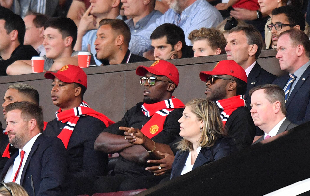
As one of the biggest football clubs in the world, Manchester United have countless celebrity fans. Those who have been spotted watching matches at Old Trafford include:
Usain Bolt
Usain Bolt is a huge international Man Utd fan and even once claimed that he wanted to try and play professionally for them once he had retired from athletics. Although Bolt never got to fulfill that dream, he has played on the Old Trafford turf as part of Soccer Aid.
Tyson Fury
Tyson Fury was born in and grew up in Wythenshawe, an area just a few miles away from Old Trafford so it was always likely that he was going to support Man Utd. Fury has spoken about potentially fighting at Old Trafford one day and has graced the Old Trafford turf with his belts on a couple of occasions.
Luke Littler
Teenage darts sensation, Luke Littler is a big Man Utd fan and used to visit Old Trafford frequently before his weekends were taken up by winning darts tournaments. Now he’s the world champion, he could be set to parade his new trophy around Old Trafford.
? Luke Littler on taking World Championship trophy to Old Trafford: “If they allow me to yeah! I’m glad I beat Stephen yesterday because I’m pretty sure he was taking it to Anfield on the weekend!” [@BeanymanSports]
— United Zone (@ManUnitedZone_) January 4, 2025
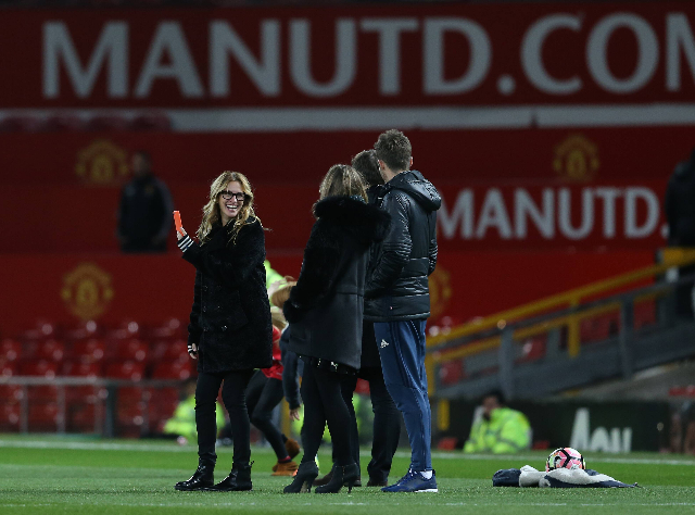
Julia Roberts
Julia Roberts is well known for being an American actress but she is also a big Man Utd fans. Whenever she finds herself in the UK, she enjoys going to matches at Old Trafford, something that Pep Guardiola has taken exception to in the past.
Manchester United have historically always had one of the biggest and best songbooks in the country. Some old classics that are often heard at Old Trafford include “Glory Glory Man United” and “Manchester United Calypso”.
One modern Man Utd chant that is frequently heard at Old Trafford these days is “We’ve seen it all, we’ve won the lot”. Other songs you will frequently hear at Old Trafford include:
- Pride of all Europe
- It’s Carrick, You Know
- Bruno, Bruno, Bruno, came from Sporting like Cristiano
- MUFC Okay
Below is a compilation of some of the best Manchester United fan songs.
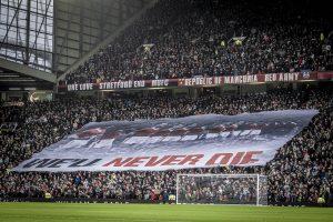
The middle tier around Old Trafford is draped with different banners relating to the club’s history. In terms of tifos, the fan group ‘Stretford End Flags’ organise them for big matches and/or occasions.
Take me home
After the success of the tifo used for the Europa League quarter-final against Lyon, Manchester United fans organised another tifo for the semi-final home leg against Athletic Bilbao.
Bruno Fernandes was central to the design of this one, requesting that the imagery used on the tifo included the whole team as opposed to focusing on just one or two of the key players.
The final design depicted the current group of players alongside the words ‘Take me home, United Road’ in reference to the chant that the club’s fans sing to the tune of ‘Take me home, country roads’.
Many fans found this one slightly underwhelming compared to the previous design, but given fans at Old Trafford are only just starting to get into the world of tifos, it’s an admirable effort.
Big thanks to everyone who submitted design ideas for the TIFO.
With some input from @B_Fernandes8, who wanted it to focus on the whole team rather than individual players or goalscorers, the design was finalised. pic.twitter.com/AlC0FzC9Mi— Stretford End Flags (@SEF_MUFC) May 8, 2025
Never gonna stop
Ahead of Man Utd’s Europa League quarter-final with Lyon during the 2024/25 season, Manchester United fans designed a brand-new tifo that was unfurled in front of the towering Sir Alex Ferguson Stand as the players walked out before kick-off.
The tifo was a sight to behold and depicted the club’s previous successes in Europe with the words ‘Never gonna stop’ written across it. This was a nod to the chant ‘We’re Man United and we’re never gonna stop’ which has grown in popularity in recent years.
“NEVER GONNA STOP.”
Manchester United’s tifo tonight. 🏆 pic.twitter.com/INStUF5d2B
— Football Tweet ⚽ (@Football__Tweet) April 17, 2025
Busby Babes surfer banner
Every February, Manchester United commemorate those who died in the Munich Air Disaster in 1958, including eight first-team Manchester United players. As part of that remembrance, a surfer banner is unfurled in the lower tier of the Stretford End.
The best views at Old Trafford can be found in the second tier of the Sir Alex Ferguson Stand towards the halfway line. Blocks N3404 and N3405 are your best bet when it comes to view of the pitch.
The upper half of tier 1 in the Sir Alex Ferguson Stand and South Stand are also excellent while the front of tier 3 in the Sir Alex Ferguson Stand is quietly underrated in terms of following the action on the pitch, even if you do feel slightly disconnected from the atmosphere.
If atmosphere is the priority, fans should try and secure tickets in the Stretford End. Both tiers in this stand generate a good atmosphere with United typically attacking this end in the second of matches.
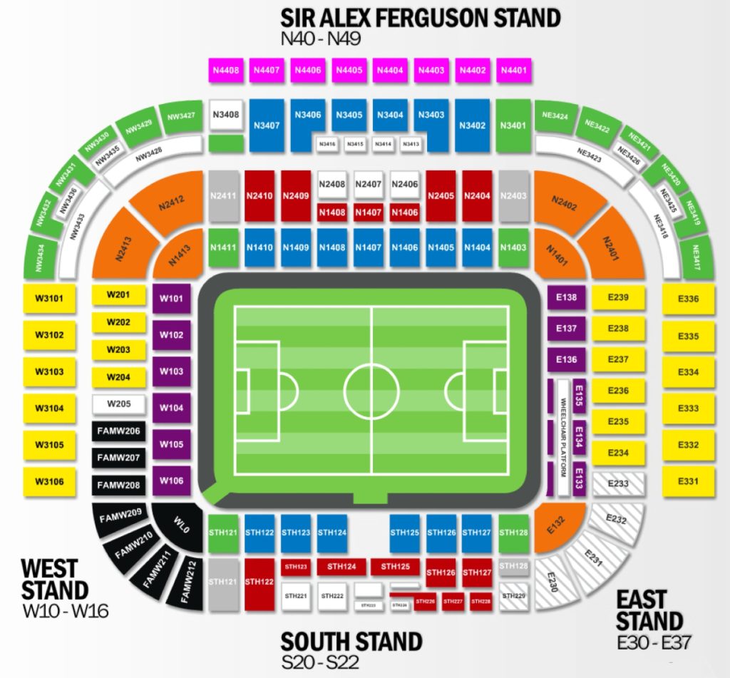
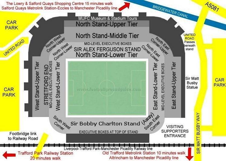
Seating plan
Entrances
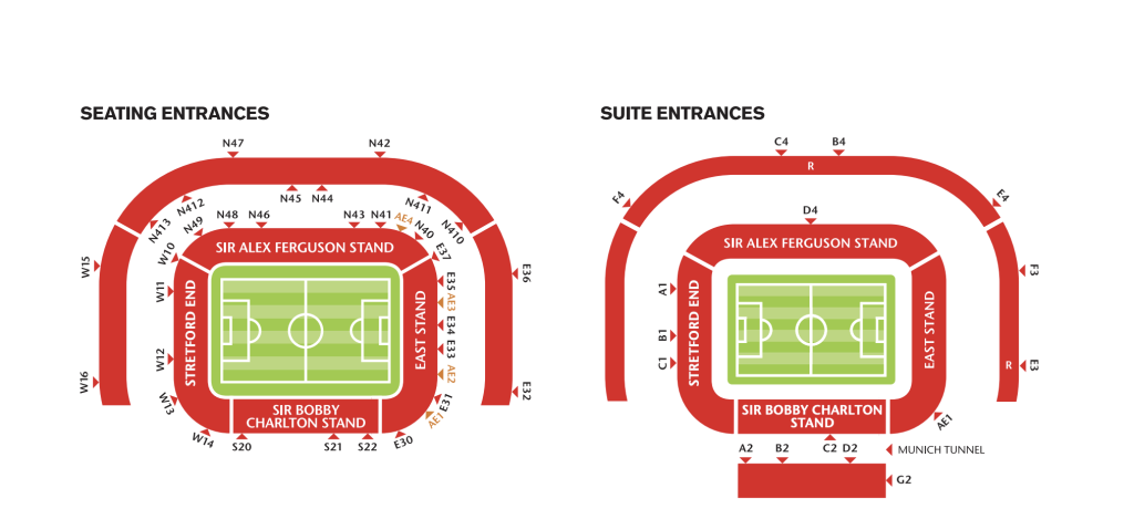
There are four entrances to Old Trafford, North, South, East and West.
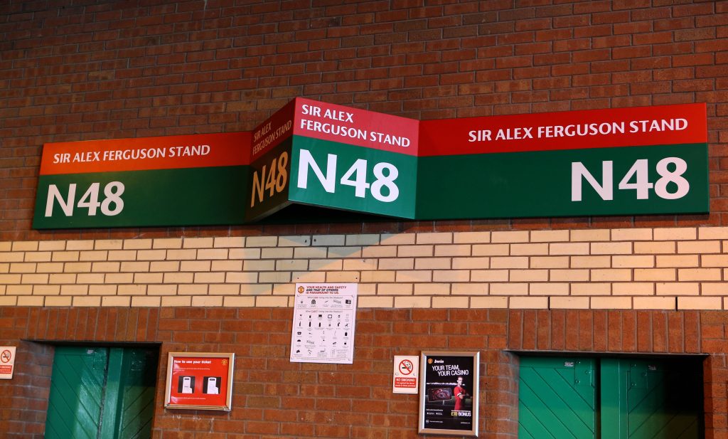 Photo by Imago
- All tickets marked with an N plus a number will enter via the Sir Alex Ferguson stand.
- All tickets marked with an E plus a number will enter via the East stand.
- All tickets marked with an S plus a number will enter via the Sir Bobby Charlton stand.
- All tickets marked with a W plus a number will enter via the Stretford End.
The image below shows the location of all Old Trafford entrances for standard tickets plus hospitality suites, courtesy of the club’s official website.
As you would expect, the pubs nearest the ground generally won’t let you in if you wear away colours. Instead, away fans tend to head for Salford Quays which is around a mile away from Old Trafford. Some options include:
- Lime Bar – Unit G1, The Quays, Salford M50 3AG
- Matchstick Man – Capital Quay, Salford M50 3WL
- The Dockyard – Media City, DockHouse, Salford M50 2EQ
While plenty of Man Utd fans will also drink in these pubs, there is rarely any animosity between supporters here.
Drinking in Manchester City Centre pre-match
Alternatively, some fans choose to drink in the Manchester City Centre or along one of the stops on the Metrolink, such as Sale (three stops from Old Trafford) where there is the King’s Ransom opposite the Metrolink station.
If the earlier news story about mice hasn’t put you off, then you can pick up some hot food from the concourses at Old Trafford. Offerings include pizza twists, hot dogs and pies.
Alcohol is served before kick-off and at half-time with Old Trafford boasting the cheapest pint in the UK when it comes to football stadia. An (albeit) warm pint of Carling only costs £3 but other options are available on a rotational basis.
Dog and a beer £6 at Old Trafford @FootyScran pic.twitter.com/YB3qsLA0v8
— UtdTrav (@UtdTrav) April 2, 2022
As you’d expect the surrounding area is littered with food vans on matchdays all offering the standard football menu of burgers, hot dogs and chips. There are also a few ‘trendier’ vans selling pizza slices and beef brisket should you want something a little bit different.
In terms of nearby restaurants, you are once again better off heading to either Salford Quays or Manchester City Centre. The quays are closer and three restaurants you will find there are:
- Banana Tree – Unit G40B, The Lowry Outlet Mall, Salford M50 3AZ
- Turtle Bay – Unit 39, Unit, The Quays, Salford M50 3AH
- 11 Central – Unit 27A-28, Quayside MediaCity, The Quays, Salford M50 3AH
Even closer is White City Retail Park, which is a haven for furniture stores. Among the sofa shops is a Nandos but as you can imagine, this fills up quickly on a matchday. Across the road is a KFC, which is typically slightly less busy.
- White City Retail Park – Chester Rd, Old Trafford, Stretford, Manchester M16 0RP
By car
From the South
Leave the M6 at Junction 19 and follow the A556 towards Altrincham. At the junction with the M56 take the A56 towards Altrincham. Keep on the A56 for six miles, and then you will come to see Sir Matt Busby Way on your left. The ground is half a mile down this road on your left, although on matchday, this road may well be closed to traffic.
From the North
Leave the M6 at Junction 30 and take the M61 towards Bolton. At the end of the M61, join the M60. Leave the M60 at Junction 9 and follow the A5081 towards Manchester. After about 3km, you will reach Sir Matt Busby Way on your right for the ground.
From the West
Follow M56 until its end and then take the M60 (W&N) as for Trafford Centre. At Junction 7 leave M60 and take the A56 towards Stretford. Stay on the A56 for two miles, then you will come to see Sir Matt Busby Way on your left. The ground is half a mile down this road on your left, although on matchday, this road may be closed to traffic.
By rail
Most fans using the train will arrive at Manchester Piccadilly, but this is 2.5 miles away from Old Trafford, so most fans won’t fancy the walk from here. If possible, there are a few closer train stations, including Manchester Deansgate (1.8 miles away) and Trafford Park (1.5 miles away).
Although Old Trafford has its own railway station located behind the South Stand, it has not been in operation for some time now, and it is unclear whether it will reopen.
By Metrolink
There are several Metrolink stops within realistic walking distance of Old Trafford. These are:
- Old Trafford
- Trafford Bar
- Pamona
- Exchange Quay
- Wharfside
The closest station is Wharfside but to get here you will need to have access to the Trafford Centre Line. The only city centre stop that runs on this line is Deansgate.
Most fans will end up at either Old Trafford or Trafford Bar and both of these are a 10-15 minute walk away from the stadium. All City centre services apart from ones going to the Trafford Centre will stop at Trafford Bar while only trams heading to Altrincham from the City Centre will stop at Old Trafford.
By boat
As Old Trafford is based on the Bridgewater Canal, there is a unique option for getting a boat to the match. Manchester River Cruises offers this service to fans from Ralli Quay near Spinningfields. Each cruise includes:
- Licensed Bar On Board.
- 30-minute journey time to Old Trafford.
- Departure time 1 hour before kick-off.
- Return 20 minutes after the final whistle.
- In operation for all Manchester United home games.
- Avoid the hassles of driving and parking around Old Trafford or going by public transport.
By bus
From Piccadilly Gardens you can get the Stagecoach Manchester Buses 255, 256 or Arriva North West No 263. These services all run down the A56 Chester Road near to Old Trafford. Journey time (depending on traffic) is around 15-20 minutes.
These buses can be caught from Stop L (255, 256) or Stop K (263) in Piccadilly Gardens.
By air
Manchester Airport is located eight miles away from Old Trafford. You can either get a taxi from the airport (cost around £30) or catch one of the regular Metrolink trams from the Airport to Trafford Bar, which is around a ten-minute walk away from Old Trafford.
Car parking
Fans can purchase car parking permits via the club website, providing they have a match ticket, but spaces are limited. However, it is more cost-effective to use one of the numerous pop-up car parks that are in operation on a matchday for much cheaper than what the club will charge.
Alternative options include parking for free at one of the Metrolink stations near the stadium including Parkway, which has a free park-and-ride facility, or use the multistory car park at the Lowry Shopping Centre at Salford Quays. The big Tesco on Chester Road is another secure place to park.
The current capacity at Old Trafford is 74,879, but this is a figure that has fluctuated over the years.
The club first moved to Old Trafford in 1910 and the stadium was unrecognisable to what it looks like now. Despite it looking smaller on the face of it, the stadium had a capacity of around 80,000 when the club first moved due to the fact it was standing only.
After the stadium was bombed during the Second World War, the club had to rebuild Old Trafford from the ground up. The stadium re-opened in 1949 with a similar capacity, but over the course of the 1950s, 60s, and 70s, it was scaled down to around 60,000.
The Hillsborough disaster in 1989 forced all clubs to turn their stadiums into all-seaters which cut the capacity at Old Trafford further to 44,000, however, it didn’t take them long to start scaling up.
A new tier was added to the North Stand in 1995 to boost the capacity to 55,000 and not long after second tiers were added to the East and West Stands to make the capacity 68,000.
The final expansion took place in 2006 when the North-East and North-West quadrants were expanded. This took the capacity to 76,000, but in recent years, this has been reduced slightly due to an expanded wheelchair area.
To go two decades without improving or expanding Old Trafford is certainly alarming, and logistical issues related to the railway track behind the South Stand haven’t helped.
The current capacity of each stand at Old Trafford is as follows:
- Sir Alex Ferguson Stand (North) – 26,000
- Sir Bobby Charlton Stand (South) – 11,500
- Stretford End (West) – 12,000
- East Stand – 11,500
- North-East quadrant – 5,000
- North-West quadrant – 5,000
Old Trafford is as much a tourist attraction now as it is a football stadium and stadium tours are in hot demand. Tours operate every day of the week except matchdays.
Using the official club website is the best way to secure your place whilst costs are as follows:
- Adult – £36
- Over 65s – £26
- Under 16 – £20
- Under 3s – Free
As part of each tour, fans get a behind-the-scenes look at Old Trafford from the dressing rooms and press room to the hospitality and tunnel. Fans then get to experience what it’s like walking out on to the pitch at Old Trafford where they are then given a look around the dugout.
Throughout the tour, your guide will provide you with lots of information and tales from the past about a club steeped in history. To top it off, each tour ends with a look around the Manchester United museum.
There are two huge shopping centres that are relatively close to Old Trafford with the Lowry Centre just a short walk away and the Trafford Centre 15 minutes away on a tram. Other attractions nearby that are worth visiting if you are in Manchester for a few days include:
- ITV and BBC studios
- The Imperial War Museum
- The Lowry Art Gallery
- Old Trafford Cricket Ground
- Chill Factore
- Sale Water Park
There is also the National Football Museum in Manchester City Centre which has moved from Preston in recent years. Here, you will learn all about the history of the beautiful game.
Old Trafford has undergone so much renovation work over the years that it is now unrecognisable compared to what it used to look like.
Old Trafford in the 1960s
An aerial shot of Old Trafford (1966) #MUFC pic.twitter.com/TQyznqzUkB
— ?? (@ManUtdHeritage) November 14, 2021
Old Trafford in the 1980s
The old Scoreboard End at Old Trafford 1980s #ManUtd #MUFC pic.twitter.com/lHWGwiy6gT
— Terrace Images (@TerraceImages) January 15, 2018
Old Trafford in the 2000s
Concerts at Old Trafford are now a rarity with most big artists electing to either play at the Cricket Ground down the road or at the Etihad Stadium if they are playing a stadium show in Manchester. This is largely due to the lopsided nature of Old Trafford, which makes it awkward for a concert.
A cynic may suggest that its inability to host concerts and other events on a regular basis is a major reason why the club have opted to build a brand-new stadium over renovating the existing one.
Nevertheless, there have been some huge artists play at the stadium over the years, including:
Bon Jovi
Bon Jovi sold out Old Trafford back in 2003 as part of their Bounce Tour. The hit band have toured the UK on several occasions since and played at the Cricket Ground in 2011.
Bruce Springsteen
Bruce Springsteen played at Old Trafford back in 2008 just a week after Man Utd had beaten Chelsea in the Champions League final in Moscow. Several Reds bought tickets for the gig on a whim to continue the celebrations.
Rolling Stones
The Rolling Stones were the last band to play at Old Trafford back in 2018.
The Rolling Stones at Old Trafford 2018#RollingStones #mufc #ManchesterUnited #oldtrafford #mickjagger pic.twitter.com/6ZwcoWdsVG
— MANCHESTER UNITED FANS (@Unitedfans2023) July 5, 2023
Manchester United have played at Old Trafford since 1910 but the stadium has undergone several changes over the past 115 years, some of which have been beyond their control.
The original incarnation of the stadium was rebuilt in the 1940s after it was bombed during the Second World War. After re-opening in 1949, the stadium has evolved steadily over the years with floodlights being installed in 1957 and roofs fitted two years later.
In 1992, the club transformed Old Trafford into an all-seater stadium in light of the Hillsborough disaster. This left the capacity at 44,000 but over the past 25 years, this has grown to 75,454.
The ownership of Man Utd is a massive bone of contention amongst supporters. The Glazer family has been accused of neglecting Old Trafford since they purchased the club in 2005. In 2023, they revealed that they were looking to invest heavily in the stadium, which ultimately led to them putting the club up for sale.
In the end, they backtracked on a full sale, but Sir Jim Ratcliffe’s INEOS were still able to purchase 25% of the club. As part of that deal, all sporting operations were handed over to INEOS, and they pledged to invest hundreds of millions into redeveloping Old Trafford.
As mentioned earlier, the club have now committed to building a brand-new stadium which will have a capacity of 100,000. There are a few obstacles for the club to get past first, mainly in relation to the nearby train terminal, which they need to purchase to make their plans a reality.
Man Utd vs Liverpool rivalry
There is no love lost between these two clubs. Manchester United’s stadium is always a special place when Liverpool visits, but the derby isn’t all about making sure the Reds stay off “their ******* perch.”
Just generally, the two cities don’t exactly see eye to eye with the development of the Manchester Ship Canal a big part of that.
Way back, Liverpool thrived on being a port city. The Manchester Ship Canal allowed boats to bypass Liverpool and head directly to Manchester. It was seen as a double whammy for Liverpool; they’d lost a significant element of their trade from the ships, but their neighbouring city, Manchester, was getting money poured into it and thriving as an economic centre.
It’s never been forgotten, nor will it be whilst players keep ramming it down the fans’ throats – we don’t blame them either.
Man Utd vs Man City rivalry
Manchester is only home to two major football clubs so it’s little surprise that there is some tension between them. There always has been but it’s peaked and fallen through the years as life on the pitch has looked very different for the clubs; that’s in both directions at various points too.
Denis Law – a United legend – arguably gave United their lowest moment in the fixture as he scored as a Man City player to all but relegate United. Sir Alex Ferguson and the Class of 92, however, gave Man United some rather good times with a period of absolute dominance. Recently, City have bitten back, but will they ever be United? That’s the question.
Modern all-seated attendance record
76,098 vs Blackburn Rovers
Premier League, 31 March 2007.
Stadium record attendance for a football match
76,962 – Wolverhampton Wanderers vs Grimsby Town
FA Cup semi-final, 25 March 1939.
Average attendances
- 2024-2025: 73,815 (Premier League)
- 2023-2024: 73,534 (Premier League)
- 2022-2023: 73,815 (Premier League)
- 2021-2022: 72,922 (Premier League)
Ticket prices for Man Utd matches at Old Trafford for the 2025/26 season have received a hike, as INEOS continue to look at ways to raise funds for the playing squad.
For the first time in the club’s history, tiered pricing will be used based on the opponent. The prices are as follows:
- Category A: £59 – £97 (6 x PL fixtures)
- Category B: £57 – £86 (11 x PL fixtures)
- Category C: £37 – £60 (2 x PL fixtures)
- Category D: £32 – £52 (cup fixtures only)
- Official Programme: £3.50
- United We Stand: £4
For details of disabled facilities and club contact at the ground please visit the relevant page on the Level Playing Field website.
Ground Layout
Why were you looking forward to this game and visiting the ground itself?
How easy was your journey/finding the ground/car parking?
What you did before the game pub/chippy etc, and were the home fans friendly?
What you thought on seeing the ground, first impressions of away end then other sides of the stadium?
Comment on the game itself, atmosphere, stewards, pies, facilities etc..
Comment on getting away from the ground after the game
Summary of overall thoughts of the day out
Why were you looking forward to this game and visiting the ground itself?
How easy was your journey/finding the ground/car parking?
What you did before the game pub/chippy etc, and were the home fans friendly?
Manchester United v Wolverhampton Wanderers
Premier League
Saturday 1st February 2020, 5.30pm
Andy Bolland (Neutral)
Why were you looking forward to this game and visiting Old Trafford?
We had been given free tickets and chose this as we thought it may be quite open with plenty of goals! How wrong we were but still a decent game to watch despite ending 0 -0.
How easy was your journey/finding the ground/car parking?
We drove from Northampton up the M6 toll which was nice and clear. After a bit of research we plumped for parking at the car park at Altrincham station next to the ice rink. We paid £5 for all-day parking and jumped on a tram at a cost of £4 return. This dropped us outside Old Trafford cricket ground and it was a straight line 5 minute walk to the ground. It worked a treat!
What you did before the game pub/chippy etc, and were the home fans friendly?
There is a fanzone at the cricket ground but we went straight up to the ground. The ground opens early and up until an hour before kick off drinks are on happy hours to pretty much half price. Walking up fans are all mixed up and no issues. There are plenty of places for food on the street too.
What you thought on seeing the ground, first impressions of away end then other sides of Old Trafford?
The ground is impressive and at its best the atmosphere is great. Most of the game was fairly subdued as Man Utd aren't having the best season. The noise when new signing Bruno Fernandes was announced was, however, deafening from the home support! The Wolves fans were in good voice too.
Comment on the game itself, atmosphere, stewards, pies, facilities etc..
A 0-0 draw, but it was pretty much end to end so it wasn't a bad one to watch. The stewards were friendly and the facilities were good.
Comment on getting away from the ground after the game:
This was better than expected. At the tram station at Old Trafford, most people were heading towards Manchester City Centre rather than Altrincham. We waited about 20 mins and then we were on a tram and back to the car. Getting away from the car park was a doddle. Make sure you have your tram ticket though as they are inspected at a turnstile prior to getting on the tram!
Summary of overall thoughts of the day out:
A good day out despite no goals!
Manchester United v Norwich City
Premier League
Saturday 11th January 2020, 3pm
John Holland (Norwich City)
Manchester United v Colchester United
League Cup Quarter Final
Wednesday 18th December 2019, 8pm
Martyn Stimson (Colchester United)
Why were you looking forward to this game and visiting the Old Trafford Ground?
Watching Colchester play at Old Trafford! I'd been to the ground several times before watching England but never seen Man Utd play there, let alone Col Utd!
How easy was your journey/finding the ground/car parking?
Made good time in the car and stopped in Altrincham with a few hours to spare. From there we took the tram which stopped right outside Old Trafford Cricket Ground and it was then a 10 minute walk to the stadium.
What you did before the game pub/chippy etc, and were the home fans friendly?
Having parked up in Altrincham we decided to visit a few pubs there. The first stop was a bar called Pi. It had several real ales on tap and a wide variety of bottled German and Belgian beer. Next stop the Belgian Bar. It similarly had beer on tap and bottles, mostly Belgian. Then we headed to the Jack in the Box within the Altrincham Indoor Market. It was a large square-shaped room with stalls around the edges and tables in the middle. The Jack in the Box had a good range of unusual real ale. Next to that was a stall with interesting wine. There were various food stalls (pizza, made and cooked on site), an excellent pie and mash stall, an artesian bakery, chips and hot dog stall, pastie stall, even one cubicle set aside for younger children with a safe play area and toys for the youngsters. An excellent place.
What you thought on seeing the ground, first impressions of away end then other sides of the Old Trafford Stadium?
Old Trafford is an imposing ground (compared to the usual places Colchester play at). The away fans were in the upper tier of the East Stand, it was busy and everyone stood for the whole of the first half without being hassled by stewards. It was an excellent view and an impressive stadium.
Comment on the game itself, atmosphere, stewards, pies, facilities etc..
Both sides had put out first teams and the match was a bit one-sided. Man Utd sat back and were clearly playing out for penalties in the first half, then early in the second half they caught Colchester on the break and Rashford opened the scoring. Colchester replied quickly with Jackson smashing one home but Man Utd then scored a second through Martial before Colchester got a grip on the game and started pushing on more. Sadly they couldn't break them down. Well that's how I remember it anyway! 🙂 There were large queues for the facilities and no indication of anything beyond the standard terrible football food/drink available inside the ground. The stewards were friendly enough.
Comment on getting away from the ground after the game:
After the match, we headed back to the tram at the cricket ground and we got away reasonably quickly (maybe a 20 minute wait for the tram) as we were going the opposite way to most of the queue. Fifteen minutes later we were back in Altrincham and heading home.
Summary of overall thoughts of the day out:
A good night out, despite the result (which was expected). Impressive ground but standard low quality of facilities in and around the ground (although plenty of choice outside at least). Altrincham's proximity was a great find though!
Manchester United v Aston Villa
Premier League
Sunday 1st December 2019, 4.30pm
Martin H. (Aston Villa)
Manchester United v Brighton & Hove Albion
Premier League
Sunday 10th November 2019, 2pm
Joseph Ross (Brighton & Hove Albion)
Why were you looking forward to this game and visiting the Old Trafford Ground?
I'd not been to Old Trafford before, plus being able to get tickets to big away games for us non-season ticket holders is a rarity. Also, Brighton had been in good form and United the opposite.
How easy was your journey/finding the ground/car parking?
I live in Leeds so it was only an hour on the train into Manchester Picadilly then I used the metro to get to Salford Quays.
What you did before the game pub/chippy etc, and were the home fans friendly?
I met my friend for a drink in the Lime Bar in Salford Quays where there was a good mix of home and away fans. The United fans we encountered were all very friendly pointing us in the direction of the ground. About a 15 – 20 minute walk from Salford Quays and we were at the turnstiles.
What you thought on seeing the ground, first impressions of away end then other sides of the Old Trafford Stadium?
The views of the playing surface from the away end are very good and we were able to create a decent noise from where we were stood. However, the stadium could do with a few upgrades. Some parts looked very old and worn out. Despite this the scale of the ground is very impressive.
Comment on the game itself, atmosphere, stewards, pies, facilities etc..
Brighton never really got going with United creating the early chances and going 2-0 up at half time despite some questionable VAR interference (or lack of). Albion responded in the second half with a Lewis Dunk header but United quickly restored their 2 goal lead through Marcus Rashford and held on for a deserved victory.
Comment on getting away from the ground after the game:
We headed back into Manchester city centre via the metro (around 10 minute walk to the stop from the away end) and found a pub called 'The Waldorf' not too far from Picadilly station to watch the Liverpool v Man City game. Eventually got back to Leeds at around 8:30 pm.
Summary of overall thoughts of the day out:
An enjoyable day ticking off a new ground despite the result.
Manchester United v Watford
Premier League
Saturday 30th March 2019, 3pm
John Wilson (Watford)
Why were you looking forward to this game and visiting Old Trafford?
Watford have been excellent away this season, Liverpool and City excepted. I really fancied our chances against a United team that have been disappointing recently.
How easy was your journey/finding the ground/car parking?
I used an app for a parking space about ten minutes walk from the ground. I had no issues travelling up on the motorway.
What you did before the game pub/chippy etc, and were the home fans friendly?
No problems from the home fans. I covered up colours and had a few drinks in the Old Trafford Sports Club. I would recommend getting double or triple rounds in as the queues were very long.
What you thought on seeing the ground, first impressions of away end then other sides of Old Trafford?
I have to say that it feels more like a tourist attraction like the Tower of London than a football ground. Lots of various Del boys selling ubiquitous half and half scarves. I tried haggling after the game to buy one for a mate and they can get very aggressive. I would recommend any tourists to avoid them and buy merchandise in the official shop which is only a short walk away, rather than giving hard earned money to these shysters.
Comment on the game itself, atmosphere, stewards, pies, facilities etc..
Watford played their hearts out and dominated the game. United were forced to play on the counter-attack and scored both their goals this way against a second string Watford defence. Facilities were very basic especially considering how rich the club is. Watford fans were in full voice throughout. As I am sure everyone knows the home support is very disappointing, unlike their away support.
Comment on getting away from the ground after the game:
It took about 40 minutes to get out and on to the motorway. Not great but not the worst.
Summary of overall thoughts of the day out:
Although we lost I was very proud of the performance. Post Alex Ferguson Man Utd feels more like a brand than a football club. Maybe Ole Gunnar Solskjær will change that.
Manchester United v Reading
FA Cup Round 3
Saturday 5th January 2019, 12:30pm
William Biss (Reading)
Manchester United v Tottenham Hotspur
Premier League
Monday 27th August 2018, 8pm
Keith Clark (Tottenham Hotspur)
Manchester United v Southampton
Premier League
Saturday 30th December 2017, 5.30pm
David Sims (Southampton fan)
Manchester United v Manchester City
Premier League
Sunday 10th December 2017, 4.30pm
Stephen Welch (Manchester City fan)
Manchester United vs Newcastle United
Premier League
Saturday 18th November 2017, 5.30pm
Christopher Johnston (Newcastle United fan)
Manchester United v West Bromwich Albion
Premier League
Saturday 1st April 2017, 3pm
Steven Roper (West Bromwich Albion fan)
Why were you looking forward to this game and visiting Old Trafford?
I've been to Old Trafford many times over the years, the first time being in 1974. But this was my first visit for several seasons.
How easy was your journey/finding the ground/car parking?
I travelled on one of the official coaches from The Hawthorns. The coaches park up on the car park just outside Old Trafford and it is then just a two minute walk to the away supporters' turnstiles. For those travelling by car we passed quite a few car parks on the industrial areas between the motorway and the ground.
What you did before the game pub/chippy etc, and were the home fans friendly?
We went straight into the stadium from the coach park and had a drink and food there. Fans were mixing freely outside the ground and it was a decent atmosphere.
What you thought on seeing the ground, first impressions of away end then other sides of Old Trafford?
Old Trafford is huge in comparison to others in the Premier league. Three of the stands tower over the pitch, and the view from the away supporters section is excellent. My only complaint is that there is little leg room in the seats, and the seats themselves aren't particularly big. The concourse isn't all that big either, but it has ample food bars. Home and away fans are separated by a low fence, a narrow sterile area, and a line of stewards and Police.
Comment on the game itself, atmosphere, stewards, pies, facilities etc..
From our point of view the 0-0 was a decent result as we spent most of the game defending. But the atmosphere wasn't as it once was at Old Trafford. The home fans weren't particularly noisy and there was no banter between the two sets of fans. Because the view is so good from the seats there is no reason to stand, but most of the fans still do. The stewards did their best to make everyone sit but in the end they just gave up. The stewards were all friendly and good natured. Food and drink was much the same price as it is at other grounds, and there is a vegetarian option in the way of cheese and onion pasties. The matchday programme is excellent.
Comment on getting away from the ground after the game:
Straight out of the ground and a two minute walk to the coach is the easy part. An hour later we were sat in traffic – still outside the ground! When we did eventually start to move it was very heavy going all the way back to the M6.
Summary of overall thoughts of the day out:
A well fought for point and seeing the ground made this an excellent day out. Apart from the disappointing atmosphere and tight leg room I can't really find fault with the ground. I think every football fan should visit Old Trafford at least once in their lives.
Manchester United v AFC Bournemouth
Premier League
Saturday 4th March 2017, 12.30pm.
Paul Sheppard (AFC Bournemouth fan)
Why were you looking forward to this game and visiting Old Trafford?
I had just returned from holiday the day before so this was something to look forward to, especially after the bomb scare debacle of the previous season when we ended up watching the match in a sparsely populated away end in a generally strange atmosphere.
How easy was your journey/finding the ground/car parking?
Very easy as I cycled the five miles from my home (I'm an exiled Cherry), which was a first for me, cycling to a football match!
What you did before the game pub/chippy etc, and were the home fans friendly?
I wanted to pick up some tickets from the nearby Lowry Theatre so I parked my bike near there and just got a coffee from Pret A Manger in Media City before walking the ten minutes from the Lowry to the Old Trafford ground.
What you thought on seeing the ground, first impressions of away end then other sides of the Old Trafford Stadium?
I had been to Old Trafford several times before and this was my fourth visit for a Bournemouth game but this time the atmosphere was much better and the view from the section I was in (E231), was excellent. The ground is obviously spectacular if a little quieter than one might expect.
Comment on the game itself, atmosphere, stewards, pies, facilities etc..
As others have said the home fans don't generate a great deal of atmosphere (typical of many of the bigger clubs in the Premier League) but the away end was buzzing, increasingly so as the match was action packed. Unsurprisingly United took the lead (a fortuitous goal scored by Rojo) but we equalised before half time through a well taken Josh King penalty. Shortly after it all kicked off and Surman for Bournemouth, ended up getting sent off (unluckily, by general consensus) for a second yellow after an 'altercation' between Tyrone Mings and Ibrahimovic. We then had to play almost an hour (if you include injury time at the end of each half) with 10 men and the draw we achieved was celebrated like a victory. Boruc was the pick of several heroic performances. Didn't have any food or drink but stewards were friendly enough and there was no attempt to ask the away fans to sit down during the match.
Comment on getting away from the ground after the game:
I walked ten minutes back to Media City for my bike and then cycled past the metro that I would have otherwise caught back to Eccles. I cycled past Eccles Station at pretty much the same time and I was home within an hour of the match ending: Cycling is definitely the way to travel to and from Old Trafford, although I appreciate this not practical for the vast majority of away fans!
Summary of overall thoughts of the day out:
Excellent day out: everything you would want from an away day with the exception of three points (although I was delighted to come away with a point, especially as United should have won by some distance). If you get a choice of where to sit inside Old Trafford, I would go for Block E231 if it is available. Here's hoping I get to go again in next season….
Manchester United v West Ham United
Football League Cup Quarter Final
Wednesday 30th November 2016, 8pm
Daniel Turner (Groundhopping the 92)
Why were you looking forward to this game and visiting Old Trafford?
I was looking forward to it because to be honest Old Trafford is a ground that I'll probably never have the chance of visiting for a very long time! A West Ham fan I knew had a spare ticket for the away end which I didn't mind so I got that and a lift up there for just £20! A bargain!
How easy was your journey/finding the ground/car parking?
We left Braintree at 2:15pm. I expected to be there just after six, however the traffic on the M6 was awful and we didn't park near Old Trafford until 7:30pm. Over an hour later than what we expected! Please book a car park space in advance, like we did,otherwise you'll be stuck finding one! This ensured we made the kick off!
What you did before the game pub/chippy etc, and were the home fans friendly?
Not a lot really I had just 20 minutes to get into the ground so it was a dash from the car park and getting a scarf for my collection to finding the turnstile as I just wanted to get inside as soon as possible! I've never climbed so many stairs, so quickly!
What you thought on seeing the ground, first impressions of away end then the other sides of Old Trafford?
My first impressions of Old Trafford were good as I had imagined. In fact I couldn't quite believe that I was actually there!
Comment on the game itself, atmosphere, stewards, pies, facilities etc..
The game was great. There have not been many times recently that Old Trafford is treated to five goals in 90 minutes. So I was happy with the result and seeing a few goals! Atmosphere was better from the West Ham fans to be honest.
Comment on getting away from the ground after the game:
Pretty easy walks back to the car but took over an hour getting out the city but once back on the M6 south it was a stroll and I was in my warm bed at 3:05am.
Summary of overall thoughts of the day out:
A good day out that was almost ruined by turning up very late, I was worried I was going to miss loads of the game as traffic was atrocious and if it wasn't for a 8pm kick off we would of missed the first goal if it was a 7:45 kick off. But I was lucky enough to see out the full 90 minutes.
Manchester United v West Ham United
Premier League
Sunday 27th November 2016, 4.30pm
David (West Ham United fan)
Why were you looking forward to this game and visiting Old Trafford?
With Old Trafford being the biggest club ground in the country, I was excited to finally visit the stadium.
How easy was your journey/finding the ground/car parking?
The public transport in Manchester is excellent. The trams are really good and from my hotel near the airport it was a simple journey to the Salford Quays area.
What you did before the game pub/chippy etc, and were the home fans friendly?
We met and drank in the Lime Bar. Mainly home supporters but they also serve away fans and there was no trouble whatsoever. Filled up with hammers nearer kick off and a good atmosphere. No issues and good friendly banter between supporters. Went in the Matchstick Man earlier on, but more of a restaurant than a pub. As the tram system is so good, you could also drink in the City Centre beforehand.
What you thought on seeing the ground, first impressions of away end then other sides of Old Trafford?
Old Trafford is an immense stadium, absolutely massive. The away end was a little cramped but I've been to far worse. Concourse was adequate but a little on the small side. Can't remember what they were selling pints for… don't generally drink in the stadiums but the stewards were good enough. No trouble.
Comment on the game itself, atmosphere, stewards, pies, facilities etc..
Old Trafford is very quiet. Obviously the away end is noisy but it's quite disappointing that such a huge stadium lacks atmosphere. As previously mentioned, no issues with the stewarding, can't comment on food and drink prices as can't remember (!). Game was a 1-1 draw. West Ham went one up after about 90 seconds and was a good match. Very defensive display from us. View is excellent, some parts of the away end are very high up but where we were sat was awesome. It's a spectacular arena!
Comment on getting away from the ground after the game:
The tram system puts extra staff on and although it was very busy (sheer numbers exiting the stadium) it all ran smoothly. A few mouthy home fans were trying to get a rise out of the "Cockney ****'s" but no trouble to speak of. The stadium is well served by trams and there is a mainline train station. Of course you can opt to walk a bit after the game to find a less busy stop but the trains/trams will all be busy. But nothing worse than London clubs and the underground system.
Summary of overall thoughts of the day out:
Was an excellent game, great beer and atmosphere before. Locals are legendary for their friendliness and I experienced this first hand. Old Trafford is an amazing stadium and one I'll definitely be returning to at some point in the future.
Manchester United vs Burnley
Premier league
Saturday 29th October 2016, 3pm
James Gregory (Burnley fan)
Why were you looking forward to this game and visiting Old Trafford?
After previously beating Everton 2-1 last week, and with Old Trafford Manchester being the largest ground in the league, then was going to be one of the biggest away games of the season so I was certainly looking forward to it.
How easy was your journey/finding the ground/car parking?
We were going from Preston, so travelling towards Manchester was fine however once we started to come within 10 miles from the ground the match day traffic certainly did build up. So I would advise others to leave in fair time and give yourself a bit of a cushion.
What you did before the game pub/chippy etc, and were the home fans friendly?
Before the game we had a bit of time so we decided to do a lap of the Old Trafford ground, which showed off the spectacular exterior of the stadium.
What you thought on seeing the ground, first impressions of away end then other sides of Old Trafford?
Inside the stadium, it was nice and big! Seats were quite cramped however this was irrelevant as we were standing up all game.
Comment on the game itself, atmosphere, stewards, pies, facilities etc..
The game itself was dominated by United but after and unreal game by Tom Heaton and a bit of luck ended up with Burnley scrapping a 0-0 draw which was a fantastic result for an away trip to old Trafford. The atmosphere was great in the Burnley end but the united fans were virtually unheard for 95% of the game which was awful considering the amount fans in the stadium.
Comment on getting away from the ground after the game:
Getting away from the ground wasn't as bad as getting there before the game. After staying on after the game for at least 30 minutes and then taking a 30 minute walk to the car afterwards meant that we seemed to have missed a fair chunk of the traffic.
Summary of overall thoughts of the day out:
Overall, it was a great day at Old Trafford which was added to by an even better result.
Manchester United v Liverpool
Europa League, Round of 16, Second Leg
Thursday 17th March 2016, 8pm
Rob Lawler (Liverpool fan)
Why were you looking forward to this game and visiting Old Trafford?
It was a big game between two bitter rivals in the first meeting between us in Europe. Liverpool had a great chance of going through with a 2-0 lead from the first leg at Anfield.
How easy was your journey/finding the ground/car parking?
A quick dash up the M62 on the Spirit of Shankly coach which went from the Rocket pub at the beginning of the motorway.
What you did before the game pub/chippy etc, and were the home fans friendly?
Not advisable to drink in any local pubs especially with a scouse accent so just a few drinks before we got on the coach and then straight into the Old Trafford ground.
What you thought on seeing the ground, first impressions of away end then other sides of Old Trafford?
Old Trafford is a large and modern stadium and does look impressive at night. However their fans were a bit subdued, especially as there was a fantastic atmosphere at Anfield the previous week. The stewards were really friendly and had a laugh and a joke with the away fans.
Comment on the game itself, atmosphere, stewards, pies, facilities etc..
A funny moment before the kick off where a Man Utd fan with long hair and a green parka on decided to goad the Liverpool fans, he was then run over by a Liverpool fan in a disability scooter to great amusement in the away end! Coutinho scored an away goal on the stroke of half time which effectively ended the tie. The Liverpool fans sung non stop during the half time break. Only bad moment was at the end where a few Liverpool fans "outed" themselves in the Man Utd end by unfurling a Liverpool flag which resulted in a massive brawl and seats being ripped out.
Comment on getting away from the ground after the game:
A Police escort back onto the motorway and arrived in Liverpool within 30 minutes. I think I got home quicker than most times I have been to Anfield.
Summary of overall thoughts of the day out :
A good night out tarnished by a few idiots on both sides fighting at the end. surprised that the police let us walk out at the final whistle and run the gauntlet back to the away fans coach park.
Manchester United v Southampton
Premier League
Saturday 23rd January 2016, 3pm
Alex Squires (Southampton fan)
Why were you looking forward to this game and visiting the Old Trafford ground itself?
We have been getting some brilliant results at Old Trafford recently, like the win last season or the 1-1 draw the year before. With a recent upturn in fortunes on the pitch and the fact Charlie Austin was set to make his saints debut, there was reason to be optimistic.
How easy was your journey/finding the ground/car parking?
As we live up near Leeds as exiled fans, we would be facing a shorter journey than most Saints fans. We used the Transpennine express train from Leeds into Manchester Piccadilly station, so fairly straightforward.
What you did before the game pub/chippy etc, and were the home fans friendly?
After looking around the area for any pubs as we were pretty early, we came across the Piccadilly Tavern, just up the road from the station. The pub served good food and alcohol at reasonable prices. I wore my Saints colours, but there were quite a few Saints fans present, and we received no hassle from the home fans. When we left we jumped in a black cab and made the journey to the ground pretty easy.
What you thought on seeing the ground, first impressions of away end then other sides of the Old Trafford Stadium?
The sight of old Trafford's huge stands as you approach the ground is a truly amazing sight. Once in the away end, the allocation seemed a lot smaller than it has done before. The legroom between the seats leaves a lot to be desired although we were stood up for the duration of the game. We were housed in the older stand in one corner and the sight of the other three stands is incredible.
Comment on the game itself, atmosphere, stewards, pies, facilities etc..
The game itself was extremely uninspiring for the neutral, and neither of the sides looked like scoring in the first half, but we seemed the better of the two sides. The United fans were turning on the team and van Gaal once again. In the second half, we started to play well and came close a few times but couldn't quite find the back of the net, Victor Wanyama coming the closest with a header from a corner. Saints fans were delighted to see Charlie Austin coming off the bench and within seven minutes he won a free kick at the expense of Adnan Januzaj. Fellow sub James Ward-Prowse placed a very accurate ball into the box which found the head of Austin who headed home his first ever goal in saints colours. The goal sparked jubilant scenes down the away end as Saints were on the way to an old Trafford win for the second season in a row. Down the home end however, boos were ringing out until after the final whistle while Saints fans were singing joyously. We were able to see the game through to the final whistle much to the disgust of home fans. All in all a fairly unexceptionable game until the last few minutes which were incredible.
Comment on getting away from the ground after the game:
We started to walk back towards the city centre when we saw a few buses heading for Piccadilly. We jumped on one, the 255 service. It was packed but it was also efficient, and it meant we could catch an earlier train than planned which was another bonus.
Summary of overall thoughts of the day out:
Overall a brilliant day out and a fantastic result. Will definitely return!
Manchester United v Southampton
Premier League
Saturday 23rd January 2016, 3pm
Eric Spreng (Southampton fan)
Why were you looking forward to this game and visiting Old Trafford?
I have lived in Scotland all of my life but I have supported Southampton since 1968 when I was nine years old and my father took me to The Dell. My parents had lived in Southampton when they were first married in the 1950's and at the time that I went to the Dell they were down visiting friends.
I managed to secure two tickets for the Southampton end for this game and my friend and I (a neutral) took our wives down to Manchester for the weekend. They went shopping and we went to the match.
How easy was your journey/finding the ground/car parking?
We drove down to Manchester on the Friday and stayed in the Malmaison opposite Piccadilly Station. It was no problem getting the tram out to the ground, getting off at Old Trafford tram stop beside the cricket ground.
What you did before the game pub/chippy etc, and were the home fans friendly?
We got into a pub near the ground (cannot remember what it was called !) and had a couple of pints between about 12.30pm and 1.30pm and then made our way up to the ground. Everyone in the pub was more than friendly and welcoming.
What you thought on seeing the ground, first impressions of away end then other sides of the Old Trafford Stadium?
As we walked up to the Old Trafford ground I could not believe how busy it was, fully an hour and a half before kick off. We walked all the way round the ground to soak up the atmosphere before entering at the away turnstiles at the south-east corner of the ground. The view from our 'seats' in the 5th row was absolutely brilliant. The legroom for two big guys was a bit tight, but that did not matter as we (and just about every other Southampton fan) stood for the entire match. It is a wonderful stadium, but I must admit that I really was amazed how quiet the Man Utd fans were.
Comment on the game itself, atmosphere, stewards, pies, facilities etc..
The only downside of the day was my pre-match pie, which seemed to have a bit too much gravy in it and kind of collapsed in front of me! I did not really want a pie, but we had ordered two beers, a pie, and a packet of crisps and the price was £12.10 – due to some complicated 'offer' ordering another pie and another packet of crisps brought the price down to £12 (well we are Scottish!). The stewards were first class – friendly, helpful and informed.
The game itself was perhaps not a classic, although I do not think that Ronald Koeman quite got the credit that he deserved from the media for his tactical astuteness. The atmosphere at the Southampton end was absolutely superb – I haven't sung as much in years! Saints fans were all excited about Charlie Austin's signing and chanted his name regularly. After Koeman had made the double substitution with 20 minutes to and Southampton started to get on top, the Saints fans started singing 'and we've still got Charlie on the bench', taunting the Man Utd fans that Charlie was going to come on and score the winner! Which indeed he did with only three minutes left – cue absolute bedlam amongst the 1,800 Southampton fans!
Comment on getting away from the ground after the game:
We could not believe how straightforward it was to get back into town. We made our way back to the tram stop beside the cricket ground and got straight on the first tram that came along. We were back in the pub in Piccadilly just after 5.30pm!
Summary of overall thoughts of the day out:
Living 500 miles from St Mary's I don't see too many Southampton games in the flesh, but this has to be my greatest Southampton experience. Despite Man Utd's problems they don't lose a lot of games at Old Trafford, but Koeman undoubtedly out-thought Van Gaal tactically and it was great to witness. Add to that the excitement of Charle Austin's debut and the result and it was a great day to be 'In That Number'.
Manchester United v Middlesbrough
League Cup Fourth Round
Wednesday 28th October 2015, 8pm
Adam Featherstone (Middlesbrough fan)
Why were you looking forward to visiting Old Trafford?
Getting the opportunity to visit Old Trafford is always something to look forward to and especially when you support a team from a lower league looking for a cup upset. In addition Boro were taking over 10,000 fans to the game so being part of that and experiencing the atmosphere added to the anticipation.
How easy was your journey/finding the ground/car parking?
We drove down and the traffic getting into Manchester was a bit of a nightmare. Coming from the east, the M62 was pretty much nose to tail the whole way. As this was a night game we were travelling in rush hour traffic which didn't help things so I imagine for weekend games it wouldn't be as bad. Coupled with this was the unusual decision to allow Manchester City to play Crystal Palace at home on the same night. Car parking was relatively easy. We just put Old Trafford into Sat Nav and parked in one of the private car parks which are dotted along the road leading to the ground. We paid £5 which wasn't too bad.
What you did before the game pub/chippy etc, and were the home fans friendly?
Due to the aforementioned traffic issues we didn't get there in time to go to a pub or do much before the game. A few of us were in colours and we had no bother at all from any of the Man United fans.
What you thought on seeing the ground, first impressions of away end then other sides of Old Trafford?
It is as I expected an impressive ground which stands quite isolated which adds to the effect. It didn't seem as big as I had expected given that it is home to the most successful club in the country. The away stand for this cup game was behind the goal opposite the famous Stretford End. The Man United fans weren't the best in terms of creating an atmosphere but I suppose for them it was a mundane sort of game. European nights, big Premier league games etc.. will probably be better.
Comment on the game itself, atmosphere, stewards, pies, facilities etc..
The game was, for the neutral, pretty uninspiring but was unforgettable for any Boro fan. We matched them through the whole 90 mins and into extra time and had a few decent chances to win the game. It ended 0-0 after 120 minutes and went to pens where we won 3-1. Seeing Rooney miss their first pen was just the start and then Carrick and Young (note that these were all England internationals) fluffed their lines which sparked pandemonium amongst 10,000 Teessiders and gave us one of our most memorable victories. During the game there were a few 'handbags' getting thrown around amongst supporters but stewards and police officers quickly prevented the situation from escalating.
Comment on getting away from the ground after the game:
Getting away from the ground was easy enough but unfortunately we had to endure a painfully long slog home thanks to road closures. Having said that I would have done it ten times over after this game.
Summary of overall thoughts of the day out:
A fantastic day out for any Boro fan that was there. The only down side was the travelling difficulties but was worth it for the result.
Name Paul R
Manchester United v Arsenal
FA Cup 6th Round
Monday 9th March 2015. 7.45pm
Paul R (Arsenal fan)
Why you were looking forward to going to the ground:
Because I rarely get to go to away games so the chance to go to the biggest club ground in England with just under 9,000 Gooners was too good a chance to miss.
How easy was your journey/finding the ground/car parking?
I took the official club coach and there was a fair bit of traffic north of the M6 Toll (not helped by the fact we had to go back to the services because the coach driver left some behind!) and around old Trafford. Again our driver couldn't find the coach park and we were going round in circles for a while.
What you did before the game pub/chippy etc, and were the home fans friendly?
I walked from the coach park to the ground with my Arsenal colours on full show but received no real issue from that. Apart from when I went to purchase a £3.50 programme, a United fan started singing that song about Wenger that they have (Which I will not elaborate on but most should know which one I mean) I just walked away. When entering you get your ticket checked then searched.
What you thought on seeing the ground, first impressions of away end then other sides of the ground?
I was in E336 (which is normally the home end so this review is really for cup away fans or United home fans) and you have to climb a lot of stairs to get up there and I didn't see a lift there at all. I was second row from the back and the steps there are very steep so you have to be careful. Because of the roof overhang I couldn't see much of the rest of the stadium. There was a wall between us and the home support and there is a large amount of corrugated iron on the back wall and the dividing wall which is great for banging on (though the stewards don't like it for some reason) The seats are very cramped and close together so you may end up needing to stand. I noted a lack of a video screen and the electronic scoreboard which wasn't very good at giving information and right at the back you can barely hear the PA system.
Comment on the game itself, atmosphere, stewards, pies, facilities etc..
The concourse was packed so I didn't get to order any food but I managed to get a £4 decanted Singha before getting to my seat. Arsenal fans were singing loudly even before the game had started. The match itself was a great cup game with Arsenal taking the lead through Monreal before Rooney equalised for United. In the second half, Welbeck scored and Di Maria get sent off (which because we were so far back, we could barely see it) When it comes to atmosphere, it was all created by the Arsenal fans, there was very little coming from the United fans. This was helped by the stewards being lassez-faire with us (which I later discovered one of them was an Evertonian!) only stepping in when we strayed into the aisles but that was because it was that cramped. The atmosphere was also helped by the low iron roof so there was amplification of our chanting as well.
Comment on getting away from the ground after the game:
You exit the same way you come in, through the steep steps (which the wire mesh is also great for banging) The coach park was easily signposted but finding the coach in the maze of them was hard. It was slow leaving the ground until we got back to the motorway.
Summary of overall thoughts of the day out:
A great night out, well worth taking two days off work to go. One of the best atmospheres I have ever experienced and would certainly go again if I could!
Manchester United v West Ham United
Premier League
Saturday September 27th 2014, 3pm
Jess Rumsey (West Ham United fan)
1. Why you were looking forward to going to the ground (or not as the case may be):
This was the first time I have visited the ground since 2007 where we stayed up on the final day with a goal from Carlos Tevez. I was curious to see whether we could win again, seven years on…
2. How easy was your journey/finding the ground/car parking?
I took the train from London Euston to Manchester Piccadilly where enroute I met my friend. We had a lot to catch up on and time passed travelling with predictions and analysis of previous games. On arriving at Piccadilly we got another train to Old Trafford railway station, which is only a short walk away from Old Trafford.
3. What you did before the game pub/chippy…. home fans friendly?
I'd previously visited Manchester in May for the game against City so I sort of knew my way around Manchester. I took my friend to a pub i knew of from my last visit called the Waldorf where both home and away fans were drinking.
We then got the train to Old Trafford and entered the stadium of which I then grabbed something to eat and drink. We had no trouble with the home fans. They all seemed friendly and up for some enjoyable banter.
4. What you thought on seeing the ground, first impressions of away end then other sides of the ground?
It was a long time since I last went and I seem to remember the away fans being more behind the goal on my last visit. None the less the view was good from where I was sat. The concourse was fairly spacious and I managed to get served quickly. I was fascinated by the amount of banners around the stands. And the tributes to Sir Alex Ferguson.
View From The Away Section
5. Comment on the game itself, atmosphere, stewards, pies, facilities etc..
For the first 20 minutes of the game West Ham never got out of first gear, quickly conceding 2 goals. However we managed to get a goal before half time. In the 2nd half West Ham dominated the match but unfortunately couldn't find and equaliser. Well not one that wasn't given for offside anyway!
I felt the atmosphere from the home fans was very subdued and towards the end the fans were clearly nervous. Our fans however were in fine form and supported the team pretty well. I do feel there could have been more toilets on the concourse. Having been at the opposite end to the female toilets. I had to make y way through the concourse crowd at half time. Otherwise the stewards and facilities were pretty well organised.
6. Comment on getting away from the ground after the game:
I left the game just after the final whistle and got on the train from Old Trafford to Piccadilly and was back in the town centre within 20 minutes. Of which I met my friend for our journey home.
7. Summary of overall thoughts of the day out:
Despite having lost. Our fans were pretty consistent and our team played a proud performance.
Manchester United v Sunderland
Carling Cup Semi Final Second Leg
Wednesday January 22nd 2014, 7.45pm
Rory Murphy (Sunderland fan)
1. Why you were looking forward to going to the ground (or not as the case may be):
Sunderland had won the first leg 2-1 thanks to a Giggs own goal and a Borini penalty. Sunderland had one foot in the final for the first time in 22 years. Man Utd weren't exactly in fine form so I was really confident. Old Trafford's obviously a famous stadium and this was my first visit.
2. How easy was your journey/finding the ground/car parking?
We set off from the North-East at 3pm hoping not to hit traffic. There was a bit of traffic on the M62 but apart from that the journey was fine. We reached Manchester at about 6pm. We had a cousin that lived near Old Trafford and he was fine with us parking there.
3. What you did before the game pub/chippy…. home fans friendly?
Me and my mate got a bite to eat from a burger van and headed towards the away end. The home fans seemed fine with the surrounding Mackems.
4. What you thought on seeing the ground, first impressions of away end then other sides of the ground?
The ground is HUGE. Maybe not as nicely designed as the Emirates but when you're in the stadium you can really see how big it is. Sunderland brought 9,000 fans down on a cold Wednesday night in January which is great for a club that's been in a relegation battle for the last few years. We were allocated the usual corner and the upper tier of the East Stand. I was up in the God's in the East Stand and the long climb was worth it for an incredible view.
5. Comment on the game itself, atmosphere, stewards, pies, facilities etc..
Well, what a game. United took the lead from the former Sunderland loanee Jonny Evans and the game was pretty dull. The Sunderland fans were excellent and tried to suck the ball in the net. United fans were very poor. Their away fans are excellent but very quiet at home. The game finished 1-0, 2-2 on aggregate so it went to extra-time. The game still didn't really pick up until the 119th minute. Sunderland were passing it round the box and the ball went to Phil Bardsley, he unleashed a shot and De Gea fumbled it in. We went ballistic. Just as we started singing "que sera, sera" United scored and it went to penalties. The penalties were truly awful and the penalties were 2-1 in Sunderland's favour with Rafael stepping up to take the last one to either make or break Sunderland's Wembley hopes. Mannone saved it and that was it. We were going to Wembley!
6. Comment on getting away from the ground after the game:
We stayed back for half an hour to celebrate with our fellow Sunderland fans. We got out of Manchester and the journey home was fine. We got home at 1.30am and went straight to bed!
7. Summary of overall thoughts of the day out:
What a great day. Best day I've had while supporting Sunderland.
Manchester United v Chelsea
Premier League
Monday August 26th 2013, 8pm
Marcus Walker (Chelsea fan)
1. Why you were looking forward to going to the ground (or not as the case may be):
Old Trafford is the biggest club stadium in England so naturally it’s always an away day you look out for when the fixtures are released! This would be my third time to the ground as an away fan going with Chelsea every time.
2. How easy was your journey/finding the ground/car parking?
We took the train from London Euston to Manchester Piccadilly which took a little over two hours so not too bad. From there we took a taxi to Salford Quays to find a pub before heading to the ground. The ground is huge and very impressive from the outside so naturally easy to spot.
3. What you did before the game pub/chippy…. home fans friendly?
Before the game we went to the Lime Bar in Salford Quays which was a mixture of Chelsea and Manchester United fans. There was a lot of chanting from the numerous travelling Chelsea fans and the Manchester United fans weren’t impressed and a few even came over to tell the Chelsea fans to quieten down. The police all of a sudden popped out of nowhere to keep an eye on our fans which was a bit of a shock but they only intervened a couple of times. Manchester United v Chelsea is a bit of a rivalry nowadays so it was a bit hostile walking to the ground.
4. What you thought on seeing the ground, first impressions of away end then other sides of the ground?
The ground from the outside looks very impressive. It’s huge, seating 80,000 fans and the exterior is well done. The away end is in the South East corner of the stadium where the maximum allocation is 3000. Chelsea had sold out all 3000 tickets so there was a large police presence outside the away end but it’s easy to spot because of this! There was a lot of police and sniffer dogs too which was a bit of a shock but entrance wasn’t too much of a hassle.
5. Comment on the game itself, atmosphere, stewards, pies, facilities etc..
The game was a 0-0 for Mourinho’s first away game of the season at the home of the Champions and it’s a result that all Chelsea fans would have taken prior to kick off. The atmosphere from our fans was brilliant with non stop chanting throughout. I expected a lot more of the United fans though especially the ones in the Stretford End. There was good banter between the two sets of fans and a couple of United fans were escorted out of the East Upper due to badgering from our away support. The stewards seemed friendly though. The facilities are good in the concourse and it’s spacious. The queues for food and drink were very long so we didn’t bother so we joined in with the chanting and bouncing fans in the concourse.
6. Comment on getting away from the ground after the game:
As it was an evening kick off we stayed overnight in Manchester. We headed straight back to the centre and took the tram from Old Trafford to Piccaddily station. There were long queues and it took a while. Both United and Chelsea fans were chanting at each other with a mixture of banter and hostility.
7. Summary of overall thoughts of the day out:
Overall it was a top away trip. The stadium is very good and very accommodating to travelling away fans. It would have been great to return to London with all 3 points but we’ll take a point and move on.
Manchester United v Tottenham Hotspur
Premier League
Saturday September 29th 2012, 5.30pm
Jonny Laybourn (Tottenham Hotspur fan)
Being in only my second full season of attempting to attend every week at Spurs (I’ve only just moved back to the area after a childhood-long absence) I was relishing the chance to go to see us play at Old Trafford, one of the most famous football grounds in the country. Before the game we hadn’t been bestowed with the best of records against United at their place, not having won there for 23 years. I admit I wasn’t hoping for much as I travelled to Manchester, but nonetheless I saw it as an ideal opportunity to visit both the city and the ‘Theatre of Dreams’, and hope for a shock result while having a good sing song for the lads. Every away fan enjoys a sing song!
On this particular day I came from Peterborough, and got the rather slow direct train through Nottingham and Sheffield. Not the most memorable three and a half hours of my life, but I did get into Manchester in one piece and in plenty of time.
After walking round the impressive city centre for a bit, I had lunch at a Chinatown buffet followed by a drink at the famous Lass O’ Gowrie pub near Oxford Road station. Both places come highly recommended, especially the Lass if you are a real ale drinker. I then took the tram to the ground. On first impression the tram was quite expensive at £2.50 for a single ticket, but I suppose the price is justified for the high level of investment going into the network.
There was no trouble with the home fans. They seemed to vary in attendance habits with some proudly sporting their gold season ticket badges while some fans clad in United shirts seemed to not know how to purchase tram tickets! Interesting. As a win for them was expected, general talk on the tram was of how big the scoreline would be and which of their star players would be on the scoresheet.
It took about 15 minutes to reach Old Trafford tram station, and another 15 on walking out of the station past the cricket ground to finally reach the stadium. Another peculiarity I started to witness was the proliferation of half-and-half scarf sellers, the scarves themselves being half red and half white and sporting the names of the two teams. Even stranger that many people were wearing them! It began to feel more like a tourist attraction than a game of football. Given the stadium’s capacity, I feel hardly surprised now that I didn’t see a single other Spurs fan until I arrived at the ground!
The ground itself is huge, not like any other I’ve been to, save for maybe Wembley. Outside the East Stand, where the lit ‘Manchester United’ sign is and where news correspondents pose when reporting about the club, thousands of fans posed for photos. The buzzing atmosphere outside was indicative of the prestige of the club. I walked round the outside of the ground and noticed that the South Stand was a bit older looking than the rest of the ground, but I had read before that the club cannot expand this stand because of the railway line lying more or less directly adjacent to it. I then bought a programme and went into the away section of the ground, located under the Munich memorial clock at the corner of the South and East stands.
I enjoyed a Thai beer for the Londoner-friendly price of £3.60 and took my seat about twenty minutes prior to kick off. The ground was just as impressive on the inside as it was from the outside, with imposing stands on three sides (some seats were so high we couldn’t see them from where we were) and a great view from the away section. I heard United trialled moving the away fans up into the ‘gods’ à la Newcastle but decided to drop it for this season; please don’t do it, Old Trafford has one of the best away sections in the country! Although there wasn’t much leg room, I was stood close to the away section which led to much good-natured banter between the fans.
As for the game itself, just wow. Spurs had a dream start with Jan Vertonghen playing a one-two and dinking a goal inside five minutes. We continued to dominate with the brilliant Gareth Bale grabbing a second before half-time. I stayed in my seat during the half-time period. The second half was more nail-biting: for United, Rooney came on for Giggs and they looked a different side. They got chance after chance until Nani scored impressively from a Rooney cross to make it 2-1. However a minute later we countered and Jermain Defoe was at the other end; he crossed to Bale who forced a parry from Lindegaard, inviting Clint Dempsey to tap the ball in and send us into delirium. Kagawa then finished off a good move two minutes later making it 3-2. And, despite United’s total dominance from then until the final whistle, the scoreline stayed put. Spurs had finally beaten Manchester United away for the first time in nearly 23 years!
Our fans were brilliant all game and I personally was hoarse after about half an hour; definitely the most atmospheric of away experiences I’ve had. The United fans broke into song on occasion, but ours were the more consistent of the two sets of fans! I have heard however that the Stretford End is hard to hear from the away end, so forgive me if you were at the game and you disagree! The stewards were very helpful as well, showing us our seats and letting us stand for more or less the whole game, even smiling to us as we left.
We continued to sing in our seats for about ten minutes after the game, after which the party transferred to the street. Unfortunately it quickly dissolved after we were outnumbered by the swathes of grumpy United fans in the dark! I personally then did the two and a half (ish) mile walk back to the city centre. A bit far for most, but I thought better that than waiting in the vast queues for the tram among seventy thousand disappointed Reds!
Overall, it was a perfect day as a Spurs fan. Fantastic and iconic ground to visit, easily reachable from Manchester city centre and one in which you get a great view and can easily create an atmosphere. Winning was just the icing on the cake for us! Will definitely be back next year though I’ll still be cautious of overrating our prospects, albeit less so after this great result! Manchester itself is also a lovely city with so much to do both pre- and post-match.
Manchester United v Blackburn Rovers
Premier League
Saturday December 31st 2011, 12.45pm
By Tom Croft (Blackburn Rovers fan)
Why you were looking forward to visiting Old Trafford?
Although we were expecting to go to Old Trafford and receive an absolute kicking, it had always been a ground I was determined to visit and now with a bit of money behind me, I had to go. I was really looking forward to it mainly due to all the hype connected with Old Trafford; Being such a large and famous stadium and with the fact that on Boxing Day we gained a point at Anfield (1-1 vs Liverpool) I was rather optimistic about this day out.
How easy was your journey/finding the ground/car parking?
We travelled by club coach so a very easy journey. Once we arrived we parked in the car park which was roughly opposite the away turnstiles probably about 100 yards away.
What you did before the game pub/chippy…. home fans friendly?
I asked a Police Officer about any pub's in the vicinity of Old Trafford that welcomed away supporters but he didn't know so we decided against going to find any and instead accompanied our friend who had lost his ticket to the ticket office to see if he could get it replaced. (Fortunately he managed to). We walked into the ticket office entrance – all dressed in our blue and white – and didn't have any trouble whatsoever. United fans didn't seem to bother with us too much although I imagine this would be different for teams such as Man City and Liverpool.
What you thought on seeing the ground, first impressions of away end then other sides of the Old Trafford ground?
When we first saw the ground I was amazed by it. It really is such an impressive stadium all the way around outside and inside doesn't disappoint either. The view from the away section is probably the best I have ever experienced although there isn't much leg room. The segregation however between the home and away fans wasn't massive which led to a lot of banter between both set's of fans resulting in one Man United fan being called Rooney, all good natured banter though and nothing went too far.
Comment on the game itself, atmosphere, stewards, pies, facilities etc..
The game was absolutely brilliant. United threatened a lot early on but didn't seem to have that killer instinct in front of goal. The game changed however fairly quickly when in the 16th minuted Yakubu was brought down by Dimitar Berbatov in the penalty area resulting in a penalty to Rovers which the Yak calmly slotted in to put Rovers 1-0 up. Again United poured on the pressure but couldn't find that killer goal. We got to half time 1 up and the 2nd half began much the same as it ended in the first half. Rovers then made a counter attack which resulted in Yakubu darting past former Rover Phil Jones to drill the ball through De Gea's legs to make it 2-0 to Rovers. At this point we couldn't believe it and were going wild although our celebrations were short lived as straight from kick off United pushed forward and sloppy defending allowed Berbatov to make up for giving away the Penalty and putting united back into it with a cool finish from close range. 2-1.
Ten minutes later and the same again. Sloppy defending by Rovers resulting in Berbatov cooly finishing to make it 2-2. We thought it was over then however ten minuted from time De Gea seemed clueless as he came for a cross and Grant Hanley headed it past him into the net to make it 3-2 to Rovers! United then pressed more but just couldn't break through Rovers stubborn defence. Great result for Rovers and the atmosphere we generated was electric as we were singing for the full 90 minutes. The United fan's weren't in great voice although the roar when they scored was impressive.
The facilities in the ground are very good. The concourses were very spacious and toilets clean. When in there we bought a bottle of Singha Lager (£3.20 I think for a 330ml) and a bottle of Bulmers (again £3.20 I think) so not the greatest choice of alcoholic refreshments but better value than some ground's I've visited. We had very little to do with the stewards but they seemed fairly relaxed and were helpful when helping us to our seats.
Comment on getting away from the ground after the game:
Getting to the coach wasn't a problem however once we got on the road it was a good half hour at least before we got moving properly. The roads were extremely congested so I would advise taking an extra hour out of your time for the journey away from the ground just to be safe. Once back on the motorway there were no problems at all though.
Summary of overall thoughts of the day out:
Overall I would rate this as one of my favourite away days ever. Most likely because of the result but Old Trafford really is a splendid stadium and as an away supporter a MUST visit in my opinion. The pictures on television really don't do it justice because when you're there in your seat just knowing you are in what is regarded as one of the best stadiums in the world really brings an extra buzz about the place and if you are lucky enough to get three points as we did on this particular day (however not forgetting the humiliating 7-1 defeat last season) then your day will be even better. Definitely a ground I would recommend visiting.
Manchester United v Arsenal
FA Cup 5th Round
Saturday March 13th 2011, 5.15pm
Harry Shaw (Arsenal fan)
Why you were looking forward to visiting Old Trafford?
Having only visited Old Trafford once before (for a meaningless England friendly) I jumped at the chance for a trip up to watch the Arsenal. An added bonus being they’d be even more Gunners fans there because of the bigger ticket allocation for cup games.
How easy was your journey/finding the ground/car parking?
Got the train without hassle. Getting to the ground was a doddle albeit the tram from the city centre to the ground was quite busy. Not that you mind that after a few beers on the journey up! I’m sure getting there earlier would see lesser crowds on the tram.
What you did before the game pub/chippy…. home fans friendly?
Didn’t have time to track down a pub but grabbed a burger from a van before going into the ground, standard grub, what you’d expect. Didn’t have any trouble at all from the home fans.
What you thought on seeing the ground, first impressions of away end then other sides of the Old Trafford Stadium?
You can’t help but be impressed by the ground’s exterior, as much as I tried not to! But first time visitors may be expecting too much, whilst pundits on the telly can go over the top about it. It’s a vast, great stadium, but it’s definitely not going to make your jaw drop like the Bernabeu or San Siro for example, but then that’s just my opinion. Inside the ground is even more impressive, totally enclosed, the impossibly steep stands meet the pitch mere yards from the players. It looks intimidating from the stands, I’d imagine it’d be even more so from the players’ point of view.
Comment on the game itself, atmosphere, stewards, pies, toilets etc..
Stewards were polite and helpful which was good, pointing us to our seats with a smile! Toilets were clean and big, queues for pies etc. went down quickly as far as I could tell.
The game itself was unfortunately one to forget, in typical Arsenal fashion we dominated possession had shots on target but never really threatened, one thing I suppose you could say was van der Sar had a very good game. United soaked up our pressure with little effort and scored their first on the break through Fabio, then shortly after the restart Rooney headed in from close range. Both goals came from rebounds if I remember correctly which was a bore. At half time only bottles of Singha were on sale for a mammoth 3 or 4 pounds so I gave them a miss. It was annoying they didn’t sell pints but there you go. There were the usual pies and hot dogs on sale. Despite the magnitude of the game the United fans never got going, a shame with the ‘ammo’ they’ve got at their disposal. Us Arsenal fans didn’t stop all game and towards the last 20 mins turned it up a notch chanting non stop that we won the league in Manchester, absolutely fantastic.
Comment on getting away from the ground after the game:
Getting away from the ground wasn’t a problem, however I covered my colours up after being accosted by a few Man Utd fans for a cigarette! Getting the tram back into town to get the train back was a drag, unlike at Arsenal where everyone filters out to the different tube lines/stations etc. It seemed a vast percentage got the tram back to the town centre, we eventually squeezed into about the 6th one that came along, and that was still packed like sardines. Next time we’re losing two-nil I think I’ll leave a few minutes early!
Summary of overall thoughts of the day out:
Overall a great day out as the Arsenal fans were in full voice throughout, a shame about the result but hey that’s the way it goes. It definitely won’t be my last visit to Old Trafford, thoroughly enjoyable and no trouble whatsoever.
Manchester United v Leeds United
FA Cup 3rd Round
Saturday 3rd January 2010, 1pm
By Josh Grainger (Leeds United fan)
1. Why you were looking forward to going to the ground (or not as the case may be):
It was a huge game for Leeds and a great chance to visit a famous ground.
2. How easy was your journey/finding the ground/car parking?
Because of the winter snow, we thought it was better if we travelled the day before and spend the night in Manchester, The trip to Manchester was fine. There was a tram station was just outside our hotel, which made the trip to Old Trafford easy, then walking the last half a mile to the stadium.
3. What you did before the game pub/chippy…. home fans friendly?
It was very crowded and because of the rivalry between the two clubs, we thought it was wiser to get into the ground asap. The rivalry between the clubs is massive and therefore a friendly atmosphere was in doubt. Outside the ground a Man Utd scarf seller, was friendly and gave us the advice to hide our shirts after the game and the route back to avoid trouble, however, he was the kindest that came, a young programme seller swore at us and told us his thoughts about Leeds, however as we got closer to the away section, there were more Leeds fans so, the Man Utd minority didn't act stupid and walked past.
4. What you thought on seeing the ground, first impressions of away end then other sides of the ground?
The ground is very big from the inside, however, doesn't seem like it from the outside. The lids fans were given 9,000 tickets all of which were sold and we were given the east stand upper tier and the south east corner. The stairs leading up to the upper tier were metal which created a racket and stewards weren't the most friendly, however other things were on their mind rather than to talk casually.
5. Comment on the game itself, atmosphere, stewards, pies, toilets etc..
Leeds managed to create a huge shock and won 1-0 and the game was great. The atmosphere was also fantastic with 9,000 Leeds fans singing their hearts out, however credit to man u, and it was clear to see that even the glory supporters sung and the constant singing battle rarely got out of hand. The steward in front of me was friendly and talked to us about football. The toilets had Man Utd badges everywhere ( bearing in mind that this section was the home end in league games) and the toilets were good as far as it can go.
6. Comment on getting away from the ground after the game:
The Leeds fans were kept in the ground for quite a long time after the game (understandably). There were a few Man Utd fans outside the ground, however, most were in the pubs, the 9000 lids fans all came out together and outnumbered the home support, so trouble was avoided. After a long wait for a tram we returned to the hotel and the journey back to lids was fine.
7. Summary of overall thoughts of the day out:
Definitely worth it, if you are supporting a team who isn't rivals with Man Utd, then you'll be fine and even if you are following one of man u's rivals, if you use your head, the police seem to have it sussed out…